Difference between revisions of "Radnorshire"
Jessbowbag (talk | contribs) (→Links) |
Jessbowbag (talk | contribs) (→Links) |
||
| Line 129: | Line 129: | ||
'''Maps and Photographs''' | '''Maps and Photographs''' | ||
| − | |||
| − | |||
*[http://www.british-history.ac.uk/map.asp?compid=55191 Ordinance Survey Maps of Radnorshire] | *[http://www.british-history.ac.uk/map.asp?compid=55191 Ordinance Survey Maps of Radnorshire] | ||
Revision as of 10:43, 22 February 2009
Contents
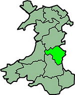
Radnorshire is an inland county in South East Wales.
Towns: Knighton Llandrindod Wells
Industry: Agriculture
Radnorshire is the smallest of the 6 counties of South Wales.
Level around the Vale of Radnor, which was forests to an extent, although these have long disappeared. The greater portion of the county is hilly, in parts mountainous.
Register Offices
Hay District
The Registry Office
Council Offices
Hay on Wye
Powys
HR3 5BX
Tel: 01497 821371
Llandrindod Register Office
The Register Office
County Hall
Llandrindod Wells
Powys
LD1 5LG
Tel: 01597 826382)
Radnorshire East Registration District
The Registry Office
West Street
Knighton
Powys
LD7 1EN
Tel: 01547 529884
Record Office Lookup Requests
Please read the Terms and Conditions before requesting a lookup.
By requesting a lookup you are agreeing to the Terms and Conditions as linked above.
Record Office Lookup Contacts
Cemetery Lookup Requests
Please read the Terms and Conditions before requesting a lookup.
By requesting a lookup you are agreeing to the Terms and Conditions as linked above.
Cemetery Lookup Contacts
Photo Offers
Members who have offered to take photographs in particular areas. Please send the member a private message with your queries.
Links
Primary Reference Links
Countywide Interest
Specific Town and Village Interest
Maps and Photographs
Back to Wales
